Research
My primary interest of study is how to model the dynamics of crime hot spots on a street network and how to use these hot spots to predict crime. The simulation model I developed uses Mathematical concepts in Graph Theory, Diffusion, and Stochastic Processes to help us better understand these concepts.
Articles
The criminal propensity to commit crime is heavily influenced by surrounding environmental factors. Determining the various aspects and features within the environment that contribute to increased criminality and the scope of their impact can further the conceptualization of the environmental backcloth. To this end, a graph model of the environmental backcloth becomes a useful tool for analyzing the various elements that form the environment. By using a graph model, analytical tools from the mathematical field of Graph Theory can be applied to the environmental backcloth. In addition, various algorithms used in Social Network Analysis can be adapted and applied to this graph model. In particular, this paper explores how the concept of reach — used in Social Network Analysis to identify central actors—can be adapted and applied to a graph model of the road network of the City of Vancouver, Canada. This analysis focuses specifically on the relationship between the presence of stores and the rate of crime near a junction. A strong correlation was found between reach to stores and reach to crime demonstrating that areas with a high store presence tend to have high crime rates.
IEEE UEMCON 2023, (accepted)
Environmental criminology has looked at how the behaviors of people, including offenders and victims, are influenced by surrounding environmental factors. The environmental backcloth, such as a road network or areas of different land uses, sets the framework for people's daily activities. Within the backcloth, there exists a connectedness of elements and layers that describe the environmental features within their varying states (static, dynamic, temporal). This paper proposes a graph model of the environmental backcloth. The development of the framework for this graph model is described, and the case studies that use this framework are presented. The benefits of using the graph model of the environmental backcloth are discussed. Some features of the framework include applying graph and social network analysis algorithms to the graph model, interactive visualization, and implementing/applying algorithms to the model.
ReadCrime Pattern Theory suggests that an offender’s daily activities shape their awareness space which in turn governs where and when they will offend. This work extends Crime Pattern Theory via temporal considerations of when crimes occurred. The model and subsequent experiments look at previous crime selection and crime weighing work to review spatial-temporal integration. Many spatial crime analytics do not include temporal consideration, other studies assign equal weight to crimes regardless of when they occur, and other work measures the correlation of temporal factors without applying them to forecasting. Building on these concepts, the proposed model develops two ways to integrate temporal factors into crime forecasting, Normal and Exponential Decay historical weights, and surveys their utility in forecasting crime in Vancouver Canada. Experimental results highlight the success of the exponential decay model and provide suggestions on what historical data should be included for crime forecasting.
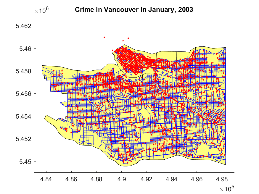
ReadThis article develops a generalizable agent-based simulation model of crime. This model is a direct application of a diffusion model of residential burglary and offender mobility by Short et al. [31] to real world crime. Offender mobility is modeled through biased random movement and crime attractiveness of a location is derived from past crimes, diffusion of information and memory decay of past events. Simulations use realistic spatial and crime data for Vancouver, Canada with an error analysis performed at the macro, meso, and micro level. The experimental results are convincing, achieving Pearson Correlation values of 0.988, 0.909, and 0.732 for each level respectively using a Truncated Levy Flight mobility framework. Without a mobility framework, we were able to achieve 0.997, 0.954, and 0.645 for these same levels.
ReadIn this article, we develop a mathematical framework to model crime and crime concentrations on a city road network. The model proposed is an advancement to similar frameworks inspired by a model introduced by Short et al. (2008). A significant modification introduced in our model is the use of spectral graph theory to represent the road network and to simulate diffusion throughout the network. The techniques discussed are tested in a simulation model of crime applied to the city of Vancouver, BC, Canada. The simulations presented are based off of empirical data of crime in Vancouver along with its street network. Results of the simulations present crime patterns that are consistent with crime patterns observed in the city.
ReadPresentations
Future Technologies Conference (2021)
Investigating Historical Crime Importance in Vancouver via Temporal-Spatial Crime Pattern Theory